Life On Krabi River Side
January 11, 2011 by admin
Filed under Attractions
Comments Off on Life On Krabi River Side
Walk The Local Path
Posted By KDSH

Early History
The early population settlement of Krabi are found along the river according to discovered archaeological evidence of ancient paintings, beads, stone tools, pottery and skeletal remains. Over the years, many local Thai natives settled and trade with the transitional monsoon traders from India, Malaya and parts of South East Asia. Most people are Buddhists with a majority as Muslims. There are many Chinese descendants in Krabi Town who can speak dialects, observing Chinese rituals and religious beliefs.
Krabi Fossilized Shell Cemetery
July 26, 2010 by admin
Filed under Attractions
Comments Off on Krabi Fossilized Shell Cemetery
Recently, Krabi has seen millions of visitors enjoying the tranquil beaches and natural wonders of the island that is evident in the achievements and environment of the people making it a top tourist destination. With several beaches and surrounding islands to explore, Krabi is a diverse and fascinating place, rich in culture, dining, shopping, nightlife, and sporting activities. Among the many places to visit in Krabi is Ban Laem Pho especially if you are interested in geological history. Ban Laem Pho was once a large freshwater swamp and home to a particular breed of snail dating back to the Tertiary Age approximately 40 million years ago when they lived and died by the million, forming layers upon layers whereby the living existed. Slowly but surely, changes in the weather precipitated the swamps’ disappearance leaving behind layers of fossilized snail shells of forty centimeters thick resting on ten centimeters of the subsoil lignite.
Read more
Krabi Walking Street.
June 12, 2010 by admin
Filed under Attractions
Krabi ” Pasar Malam “

Pasar Malam in Batavia, Indonesia, period 1900-1940
Pasar malam is a Malay and Indonesian word that literally means night market, “pasar” being related to “bazaar” in Persian. A pasar malam is a street market in Malaysia, Singapore and Indonesia that opens in the evening, usually in residential neighbourhoods. It brings together a collection of stalls that usually sell goods such as fruits, vegetables, snacks, toys, clothes, shoes, alarm clocks, and ornaments at cheap or at least reasonable prices. Pirated DVDs, CDs and computer software are often sold at a pasar malam. A pasar malam often takes place only one to a few days of the week, as the traders rotate around different neighbourhoods on different days of the week. Haggling over prices is a common practice at such markets. Pasar Malam are often differentiated by ethnicity. A Malay pasar malam will often contain stalls selling Islamic books, kopiah hats, sarongs and other Malay specialty items. Chinese pasar malam may sell Mah Jong sets, incense, joss sticks, joss paper and various Chinese prayer supplies. Indian pasar malam may contain Hindu prayer supplies. In the Netherlands, a yearly Indo Eurasian festival is held in The Hague under the name Tong Tong Fair, formerly known as the Pasar Malam Besar. Due to the big number of Indo Eurasians and the successive success of this event since 1959, dozens of Pasar Malams are held each year in the Netherlands. Recently the Indonesian embassy has started sponsoring a yearly Pasar Malam Indonesia, mainly to promote Indonesian business and enhance Dutch-Indonesian relations. Image and text source : From Wikipedia, the free encyclopedia
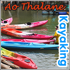
Ao Talen
July 16, 2009 by admin
Filed under Attractions

 Ao Talen is a small fishing village, located in the heart of Krabi’s local mangrove ecosystem. By paddling a canoe or kayak through the intricate waterways, you can penetrate the diverse swamps and limestone karsts, highlighted by a lagoon and canyon.
Read more
Nopparat Thara Beach
July 16, 2009 by admin
Filed under Attractions
Locals refer to Nopparat Thara as “Klong Heng” (dry canal) because of its appearance at low tide. Then it is interesting to walk to the nearby islands without needing a boat.

NOPPARAT THARA BEACH
is just North up the coast from Ao Nang, 19 km from Krabi town. It is also the longest beach in the area, 3 km long. The National Park headquarters are situated at the northern end of the beach, close to a tributary of water flowing from the mountain in the North. The office’s facilities include tourist information, bungalow accommodation and a camp site.
Railay Beach
July 15, 2009 by admin
Filed under Attractions
Railay Beach : Surrounded by sheer limestone cliffs on 3 sides, Railay Beach, just South of Ao Nang, can easily be reached by local taxi boat in 15 minutes. The name ‘Railay’ is supposedly an abbreviation for ‘Rai Tale’ in Thai, which means ‘orchard near the sea.’ Railay Beach consists of two bays joined at the headland on the West and East respectively.

Krabi Economy
July 15, 2009 by admin
Filed under Attractions


EARLY SURVIVAL
Archaeological research revealing human and animal bones, tombs, stone age tools and campfire activity, suggest that Krabi was a home to cave men, 27,000 to 37,000 years ago. Man’s methods of survival changed over the course of time from hunting and gathering to animal rearing, 3,000 to 5,000 years ago.
Ao Nang Beach
July 15, 2009 by admin
Filed under Attractions
Comments Off on Ao Nang Beach
Ao Nang Beach
Posted By KDSH

Ao Nang Beach is the collective name for a group of bays, incorporating Ao Nang, Tonsai Beach, West Railay Beach, Phra Nang Beach, Phranang Cave, Laem Nang and East Railay Beach. Ao Nang’s limestone pinnacles physically define the borders of each beach, whose only access is by boat. The name Ao Phranang seems to have its origins in the villagers’ faith and belief in a sacred ‘Pra Nang’ (princess spirit) who protects the fishermen. The first impression travelers have on arrival is, if not the dramatic backdrop of the sheer limestone cliffs, the closeness of the islands in the bay. These islands have various rock formations, taking the shapes of a chicken’s head, a junk respectively. Local taxi boats are readily available to let you explore these attractions at a moment’s notice. Barely 50 m off the main beach of Ao Nang is a concentration of shops, travel agents, bars, restaurants, accommodation and other facilities. Its wealth of conveniences and rapid development have put Ao Nang into the spotlight as the tourist center of Krabi mainland. Like all international resorts, there is a buzz of excitement, with the feeling that there’s something happening 24 hours a day.
Read more
Ao Pranang (Pranang Cave Beach)
July 14, 2009 by admin
Filed under Attractions
Phranang Cave Beach

Like Railay, the beach of Pranang can only be reached by boat, and is similarly popular for swimming and rock climbing. Pranang Cave, which often lends its name to the beach, is a small but memorable cave, shrouded in mythology and mystery. The stalactites and stalagmites are one outstanding feature. Ao Pranang is a beautiful, 600 m long beach, blessed with pure, white sands. It is quite a hot spot, and is sure not to disappoint sun lovers. Read more
Krabi Rainforest
July 13, 2009 by admin
Filed under Attractions
Krabi Rainforest
Covers approximately 9 per cent of the total land area – which is mostly established in the form of a national park and wildlife sanctuary. A guided visit to these conservation areas can be easily arranged.
 Read more