Krabi Geography
June 25, 2009 by admin
Filed under Attractions
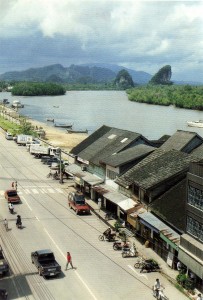
Twenty years ago, Krabi River, Krabi Town. Photo courtesy of Morag Mckerron.
Located on the western shore of the central Indochina peninsular, where the Andaman Sea lies adjacent, Krabi is blessed with plains, mountains, valleys, rainforest, mangroves, rivers, caves and islands. The coastline of Krabi is 160 km. long. It lies between a latitude of 7′ 30″ and 8′ 30″ North and a longtitude of between 98′ 30″ and 99′ 30″ East. To the North : lie the provinces of Phang Nga and Surat Thani. To the South : lie the province of Trang and the Andaman Sea. To the East : lie the provinces of Trang and Nakorn Sri Thammarat. To the West : lie the province pf Phang Nga and the Andaman Sea. Area : The province of Krabi covers an area of 4709 square km. divided into 8 districts ; Muang, Khao Phanom, Klong Tom, Plai Praya, Koh Lanta, Ao Luk, Lum Thab and Nuerklong.
TERRAIN
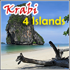
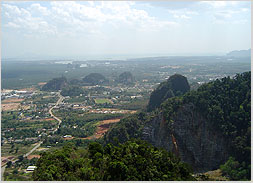
Mainland Krabi features prominently limestone outcrops or karsts, evolved from the subsidence and elevation of the earth’s crust many million years ago. According to the changing sea levels, some places which are now land, were previously submerged under the sea. Other places, which used to be plains, were transformed into many magnificient recesses after being flooded by the sea. From the highest peak of Phanom Benchar in the North East of the area, the land slopes downwards to the Andaman Sea in the West, bringing with it various sized water courses, one of which is Krabi River, running 5 km. through the town. Krabi has more than 130 islands, which can be grouped into 4 archipelagos. From North to South they are the Hong Islands, the Poda Islands, the Phi Phi Islands, and Koh Lanta. Distinguished by irregular limestone peaks, 150 to 400 feet in height, they developed in the Carboniferous to Permian era, 230 – 340 million years ago. The sea shore of Krabi is a continental shelf known as a “marine kart”. Some geologists praise Phang Nga Bay – comprising the area of Phang Nga, Phuket and Krabi – as “the world’s most beautiful marine kart”. Due to its deep coastal continental shelf, nature has created a stretch of pure white, sandy beaches, emerald seas and protruding limestone islands, with indented features eroded by water. And as if that were not pleasing enough, a broad variety of attractively colored fish and corals lie beneath the glittering waters.
CLIMATE
Affected by the South-west and North-east monsoons, Krabi has two distinct seasons, the rainy season and the dry season. The hottest period is from March to April, and the rain comes between May and December. Air temperatures in Krabi range between 16.9 – 37.3 degrees and the average annual rainfall is 2,568.5 mm.
RESOURCES
Under canopies of tropical rainforest, the diversity of Krabi’s fauna and flora is nurtured. A cornucopia of evergreen forest and mixed deciduous forest lie along the Phanom Benchar mountains. Than Bokoranee a national park and Khao Nor Chu Chi, a wildlife sanctury offer an immense variety of fauna and flora. Most of the land is a mixture of clay and sand, together with loose soil, which is very suitable for the planting and cultivation of rubber, palm, cashew nuts, coffee and coconut.
MANGROVE
The mangrove eco-system provides the sea with a healthy and abundant breeding area. Krabi’s nearby islands also comtribute to the fertility of the coast, by protecting the sediment from being scattered by a typical monsoon. In severe cases of mangrove deforestation, whether for charcoal production or shrimp farming, local fishing could be adversely affected.
MINERALS
Lignite is mined as Llongmak in Nuerklong District, Muang District and Klong Tom. Fluoride is akso mined at Klongtom Tai.
KRABI’S NATIONAL PARKS
 Phanom Benchar National Park covers 50.12 square km of forest, both deciduous and rainforest, highlighted by a steep limestone karst formed many million years ago. Than Bokoranee National Park contains 104 km of parkland, located both on mainland Krabi, covering 39.7 km and inside a marine park, covering 64.3 km.The park hosts a complete diversity of natural resources, including evergreen forests, mangrove, swamp forests and islands. Haad Nopparat Thara – Mu Koh Phi Phi National Park is a marine park that is well known for its places of interest, e.g. Nopparat Thara Beach, Ao Nang Beach, Susaan Hoi ‘ Shell Cemetery’ and the Phi Phi Islands. There are six islands in this last group : Phi Phi Don Island, Phi Phi Ley Island, Bida Nork Island, Bida Nai Island, Bamboo Island and Mosquito Island. Koh Lanta National Park covers 134 km, about 81% of which is a marine park, with numerous islands to visit. Khao Nor Chu Chi (Khao Pra Bang Kram) Wildlife Sanctuary is Thailand’s last lowland rainforest on the border of Trang and Krabi provinces. It is the source of many streams and rivers – and home to some rare and the endangered bird species, the best known of which is Gurney’s pitta. The number of bird species to be found here exceeds that of any other conservation area in the South of Thailand. Krabi Horticultural Crop Propagation and Promotion Centre has the largest local botanic collection locally. Its main purpose is to study and test both ethnic and foreign plants. It also serves as an agro-tourism site for those who appreciate botanical knowledge and beauty, especially the anthurium – with up to 60 different species.
Source : Krabi Tourism Association


